▲ 170 points
back
46 comments
Ooh, I've been investigating this lately, and I can't sleep. Here are some entries from my bookmarks:
* BART map, one minute per hexagon - http://transitmaps.tumblr.com/post/133579339455/lopato-bart-...
* Mapnificent, covering dozens of cities - http://www.mapnificent.net/
* OneBayArea, including housing prices - http://maps.planbayarea.org/travel_housing/
Huh. Mapnificent is exactly what I've been looking for recently after a change-up in local transit routes. It would certainly make it easier to eyeball "short trips" when considering the intersection of multiple transit modes, assuming it's accurate enough.
Walkscore uses a similar method for showing how long public transit would take from an address
It's a nice idea, but London is hopeless - looks like they've missed out the rail network completely. I guess other cities may be better, but you really only need to miss out one key route or mode and you change the map completely
I reckon it is because tfl is the data provider, and the rail network isn't a part of that?
I still found it very useful when looking for central accomodation with short commutes (<20') to centrally located places.
More links for you:
* Europe - https://www.washingtonpost.com/news/worldviews/wp/2015/06/05...
* A distorted map from Japan - http://chaudron.blogspot.jp/2009/04/kohei-sugiura-snakagaki-...
Awesome. But that's a low res scan. You can see a very high res scan here:
http://www.davidrumsey.com/luna/servlet/detail/RUMSEY~8~1~24...
Also, a scan of Galton's original isochronic map from 1881 is on Wikipedia; see:
I've always liked these maps that capture the ground truth for a single point in time. Here's another one I found a while back showing "Everywhere you can go in an Airplane", circa 1918, also with journey times:
http://www.blogabond.com/CommentView.aspx?CommentID=8226
(I actually pilfered it for that post from another source, but can't find the original now).
Growing up, we had a World Atlas in the house that was printed in the early 1940s. It had a little leaflet in the back with a card you could send in for an updated set of maps after the war was over.
Here is a similar map for the Roman world: http://journalofdigitalhumanities.org/wp-content/uploads/201....
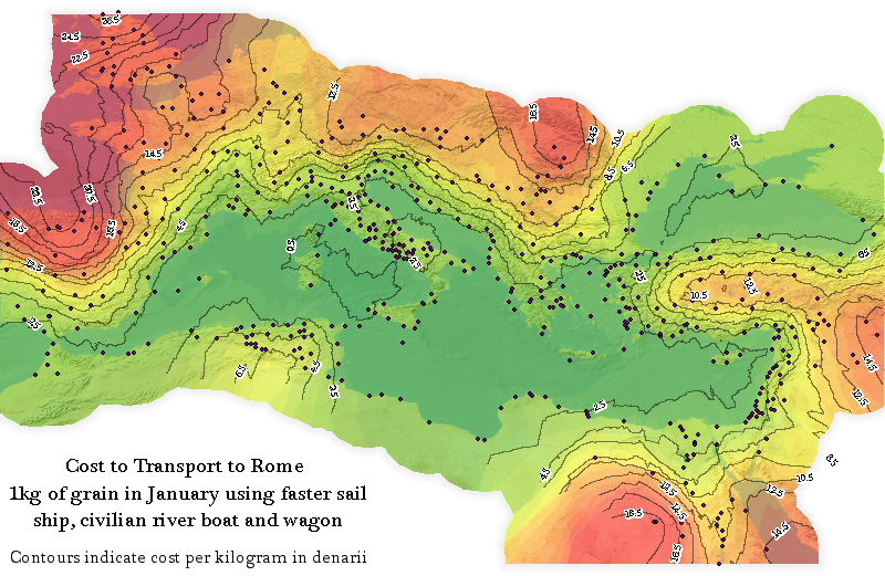
If anyone's particularly interested in unusual maps I'd recommend following @frankjacobs on Twitter. He's a collector of strange maps and tweets links to new posts on his blog. Enjoy
or /r/MapPorn
The smallest unit listed - within 5 days journey - gives an interesting perspective on the world of travel at that time.
What would we choose nowadays for an equivalent unit of "not worth listing anything below this?" Within an hour?
I'd vote for "within 3 hours". 1 hour for travel time to airport, 1 hour for boarding (hand luggage only), 1 hour for flight. Meaning: up to 500 miles. Or: 1 hour to get to railway station, 15 minutes for boarding, 1h45m on a train (meaning anything from 100 miles -- USA -- to 300 miles -- Japan, Spain, France, Germany, etc).
Your next step up is 6 hours. Flight as above, plus one transfer (1 hour) and two more hours in the air, or 4 hours on one sector. So call it up to 2000 miles. Or by rail, between 500 miles (USA: DC to Boston by Acela) and 700 miles (Tokyo to Fukuoka by Shinkansen -- actually only 5 hours).
Longest options: I can get from Aberdeen (Scotland) to Wellington (New Zealand) in a little over 24 hours, and those are within a couple of hundred miles of being antipodal points on the globe.
To take much more than 48 hours you'd need at least one end point to be somewhere either in a war zone or at the wrong end of a thousand miles of dirt track -- Raqqa in Syria maybe, or somewhere in the arse end of the Congo or the Gobi Desert.
On a world scale, an hour wouldn't get you that far, it would be eaten up by travel to / from airport. For example Charing Cross (often used as a location for the centre of London) is about 30 minutes by train / 40 by car from Heathrow Airport according to Google.
30 minutes on train from Charing Cross to Heathrow is a very optimistic estimate, I'd say 60 minutes (Picadilly line) would be more realistic.
Google routed me to Paddington (via Bakerloo) and then the Heathrow Express. I was probably lucky with departure times when I searched though.
(Heathrow Express is expensive compared to the Underground though, but if you were making this sort of map you'd probably use it as it's the faster service).
Within 5 hours would get you most of Europe.
I would put that at 8 hours. Unless Spain is especially badly connected, you are quickly at least 2 hours away from the airport. So that would be at least 4 hours slow transit + flight time.
Of course, by population density, you are probably 5 hours away from most people in Europe.
Only to major hubs, the "last (100) mile(s)" still will cost you a lot of time.
An important dimension missing in this type of map is cost of travel. If you are willing to spend sufficient money, my guess would be you could reach pretty much any spot of land on earth within about 48 hours, with the appropriate combination of helicopter and private jet... But if you limit yourself to, say, 2000 Euros, you could probably make it to many places, but it would take significantly longer.
I think you're missing the fact that this is ~1914. I bet chartering a private jet and/or helicopter back than was... difficult.
It's a great point for people who want to recreate a modern version of this map, but for 1914 I think "anywhere at any cost" is still an interesting yard-stick.
More relevant nowadays, due to the ubiquitous nature of transportation, I suspect would be seeing a map that charts not time necessary to reach a location (after all 72-96 hours would cover the overwhelming majority of the globe) from a given starting point but rather the nominal cost associated with doing so.
You'd have to define "pretty much." It's probably less than you think in terms of total landmass. There are countries and areas within countries that are restricted in various ways. There are also rugged remote areas that aren't suitable for helicopters and islands lacking airstrips.
New York based isochronic map:
http://quod.lib.umich.edu/g/genpub/abl7462.0001.001/390?view...
This is particularly interesting because it shows the advance over time.
It's interesting that you could get all the way to Hawaii quicker than you could get to the west coast of South America. There doesn't seem to be a technical impediment here, I guess there just weren't scheduled ship routes at the time?
I suspect that it simply took longer to sail around Cape Horn in South America (a dangerous and time-consuming journey) to get to the west coast of South America than it did to sail to New York, take a train to California, and hop on a ship to Honolulu.
I had assumed that a trip to Hawaii would transit the Panama Canal, but you may be right about the route. WP says the canal opened in August 1914, so it might not be included here. I wonder how different a map made just a few years later would be.
I think it's interesting that 100 years later, you could replace "days" with "hours" and the mail would look (roughly) the same.
I wonder what the next 100 years will bring...
Maybe someone will invent a real (not dup) teleporter and then perhaps it will be seconds. I've always wondered what the world would be like if you could go anywhere in seconds.
Isn't it bland and homogenous enough already?
(And then there's the risk of suicide bombers with access to teleportation pads...)
Does anybody have an idea how I could get a print of this?
Someone posted a link below to this map on the David Rumsey map collection (http://www.davidrumsey.com/luna/servlet/detail/RUMSEY~8~1~24...). You can get a high-res version there, or order a print directly.
It would be fun to see same iso-chronic map for today, 100 years since original. :)
My rough guess is that, if the units were hours, and if concorde still flew, then the map would look much the same?
You don't need the Concorde for that to hold.
London to anywhere in Europe in <4 hours, so that's the 5-days bubble.
North America was then clearly the best connected part of the world from London, this is probably still true - today New York is 6-7 hours, San Francisco ~11. Honolulu can be done in just over 20 hours.
Central Africa is obviously immensely better connected today, due to aviation. I'm pretty sure you can get to any airport served by commercial, scheduled air traffic in Africa in <20 hours, and any airstrip in Africa in the same timeframe if you're willing to charter a plane.
India is <10 hours for Mumbai, Delhi and Bangalore and Kolkata is reachable in a few more hours connecting from there. All of India is extremely well connected by domestic flights, so <20 hours should hold up fine.
For South America, Rio de Janeiro and Buenos Aires is 12 and 14 hours respectively and in Australia, Perth, Melbourne and Sydney are all reachable in <24 hours.
I suspect a modern version would have more discontinuities.
Areas near airports would be fast to reach, but onward travel from the airports wouldn't be so much faster than 100 years ago.
And the oceans would look different - it still takes a long time to reach the mid-atlantic!
Apparently trains are slower now than the used to be, I seem to remember reading something about this being the case even further back too - which isn't really surprising given how many local lines were closed.
So travel time doesn't count using a private jet and a parachute?
Even if it counted it won't be the smallest one with the time it will take to get bail in most countries.
For Europe by train see http://emptypipes.org/supp/isochrone_london/
I wish the guys from
http://www.rome2rio.com
see this and make a more precise modern version
Nice coincidence that it takes about 80 days to go around the world.
Reading the history of circumnavigation makes this seem like a bit of an overestimate -- Around the World in 80 Days was written in the 1870s, in the 1880s someone actually did the trip in 72 days, and in the early 1900s someone replicated it in 54 days.
Maybe this map represents more of an everyman's estimate. How long to get there using conventional transportation systems. The equivalent today being flying commercial and car/buses vs chartering a private jet and helicopters.