▲ 51 points
back
36 comments
Those points look like what my Dad, a farmer, would plow up in Iowa back in the 1950's. Had a box full of them. Same shape, same colors, same tang for hafting as a spear point. Lots of them.
It makes me happy when I see articles like this that indicate the "Clovis mafia" is just about gone. The care given to details of balance and symmetry in the points is just incredible.
The "clovis mafia" has been gone for well over a decade now. The idea became pretty mainstream by the early 2000s and most relevant academics were thoroughly convinced of pre-clovis by 2008 or so.
You shouldn't be too hard on them - they were working with the evidence they had on hand, just like you are. IMO, the real evidence is under 20 feet of silt somewhere off the Pacific coast.
We may be as hard on them as they deserve: they actively suppressed work, and workers, showing older occupancy than they had made their reputation on. They had no excuse: for a generation, anything older than 4kya was suppressed.
How archaeologists were able to suppress evidence for so long is a mystery.
> 4kya
I don't know where you got that number, and I apologize if it's something well known since I am in a different field, but my father did his master's thesis and a lot of subsequent work (back in the 70s) on Clovis culture, and he always represented it as at least 10K years ago. I think he would have laughed at the idea that it was 4K or less. You also have to understand that during that time there were a ton of counterculture types who were trying to push ancient origin stories that didn't align with verifiable evidence, so there was a certain amount of well-deserved skepticism in the air.
During much of the 20th century, the idea of humans in North America as long ago as the Clovis industry was anathema, what we call "career-limiting". Ask your father about how hard it was to overcome that.
Much of the resistance was, ultimately, political: if "Indians" only arrived a short time before Europeans, their claim on the land was weaker.
This is a pretty bad take. At no point in the 20th century was the idea of aboriginal Native Americans "career-limiting". It was actually the default narrative. Quoting Ernst Antevs in "THE SPREAD OF ABORIGINAL MAN TO NORTH AMERICA" (1935):
    The question of the first peopling of North America has been vigorously attacked in recent years along many lines. According to the best of our belief the findings may be summed up thus: The first man to arrive in North America was of modern type and probably at the Neolithic stage of culture. He came from northeastern Asia to Alaska and probably spread along the eastern foot of the Rocky Mountains where an ice-free corridor had formed some 20,000 to 15,000 years ago. He seems to have reached the Southwest at the age of transition between the pluvial and the post-pluvial epochs, or roughly I2,000 years ago. Reputed older finds need verification.
    All the human skeletal remains found in the Americas are, according to Ales Hrdlika, of modern types, closely resembling living Indians and Eskimos. Neither Neanderthal man nor any other primitive human species seems to have reached these continents.
They simply typo'd 14kya, a fairly typical date for the origin of Clovis.
No. Clovis is Clovis. Do not make shit up for other people to have meant.
The spiritual heirs of the Clovis hang on, still. We know there were people in North America for many thousands of years beyond 16kya. Now they are imagined not to have made any tools?
Doesn't surprise me, a large part of our historical society here in Boise revolves around the indigenous tribes in Idaho. There's a lot of activity to this day and it feels like there's always new unravelings and discoveries happening throughout the state.
Related:
Dating of a large tool assemblage at the Cooper’s Ferry site (Idaho, USA) - https://news.ycombinator.com/item?id=34111182 - Dec 2022 (10 comments)
Interesting that they mention that it looks like the artifacts may have an East-Asian (Siberian?) lineage presumably supporting the Bering crossing hypothesis.
There's pretty overwhelming amounts of evidence that ancestors of the first people of the Americas were from Northeast asia and crossed over near Beringia, though it's not clear (yet) whether that crossing was coastal/oceanic or inland Older ideas like the solutrean hypothesis are completely discredited because they're irreconcilable with a lot of distinct lines of well-established evidence.
With the width of the Atlantic Ocean, and the state of the art in long-distance ocean travel back then...is there any other credible hypothesis? I am not convinced by arguments that they hitched rides on alien spaceships.
Considering that sea levels were hundreds of feet lower back then, and waterways were critical for both transit and food gathering, it is likely that much of the record of human pre-history from this era has been obliterated. Always glad to see discoveries like this that help shed more light on our distant past.
What cities will survive in 2300.
Atlanta?
What's the biggest city that's unlikely to be underwater?
What places of our modern storytelling will be just a memory in 2300.
>What cities will survive in 2300.
That all depends on whether or not we avoid nuclear annihilation, which is a risk ancient people did not face. In the age of air travel and superhighways, human beings are much less reliant on waterways than they were in the past (though we are still reliant on them).
>What's the biggest city that's unlikely to be underwater?
Dallas, Phoenix, Denver? Hard to say which will be larger in 2300.
New Delhi. Population over 32M. Nearest ocean is 900km away.
Distance fron ocean is probable less important than elevation, but 216m seems pretty safe (not Bogota or Mexico City safe, but those are somewhat smaller cities, though not that much in the case of Mexico City.)
The realisation that sea level rises have likely obscured both the paths early humans took into the Americas and their early settlements only occurred to me recently. Though yes, it does seem highly likely. It does make me wonder what if any relics may remain beneath the waves.
Inland river valleys are the next most likely sites for early habitations and migrations. Such as this one.
In more populated regions, those are all but certainly obliterated by subsequent habitation and construction.
Sea levels 30--15 kya would have been 120--100m below present levels. Along the west coast of North America, the continental shelf drops of relatively quickly, but this would still leave a coastal plane several mile seaward of present, and some features such as the Channel Islands would have been far nearer, or even attached to, the mainland.
<https://upload.wikimedia.org/wikipedia/commons/1/1d/Post-Gla...>
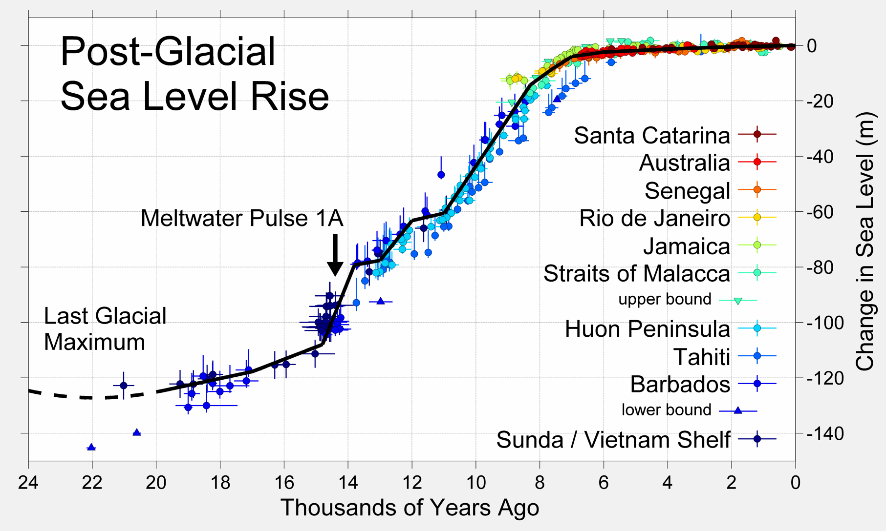
Looking at that graph, the first thought that occurs is that civilisation emerged largely as the sea-level rise stopped. Why that is I don't know.
Globally, the Earth would have appeared about like this:
<https://en.wikipedia.org/wiki/Past_sea_level#/media/File:Glo...>

I'd like to see details of the western North American coastline reconstructed. I suspect that the San Francisco Bay would have been a low inland plain with rivers running through it (the Sacramento river from the east, and likely the precursor of Coyote Creek from the south). The link below seems to confirm this --- apparently 20 kya the shoreline would have been at what is now the Farallon Islands, now 30 miles (50 km) offshore.
<https://historicalmarkerproject.com/markers/HM1QWY_20-000-ye...>
A KQED bit on evolution of the bay: <https://www.kqed.org/quest/7788/the-importance-of-studying-t...>
SF Bay shoreline evolution: <https://ucmp.berkeley.edu/ucmp_oldsite_nonwpfiles/museum/eve...>

Peak-glaciation coastline & bay: <https://ucmp.berkeley.edu/ucmp_oldsite_nonwpfiles/museum/eve...>

Both above from: <https://ucmp.berkeley.edu/ucmp_oldsite_nonwpfiles/museum/eve...>
If you go back 125kya, sea levels were higher, and there was a straight between the Bay and Pacific through Colma:
<https://cdn.kqed.org/wp-content/uploads/sites/39/2013/01/san...>
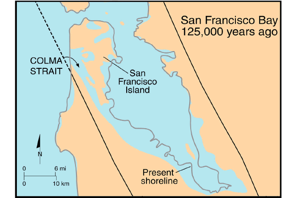
From: <https://www.kqed.org/quest/49030/geological-outings-around-t...>
California in the Late Pleistoscene (18 kya), with a fully-glaciated Sierra, many intermountain lakes especially on the east side of the Sierra Nevada, central-valley lakes, and a coastline extended far westward: <https://www.secretmuseum.net/map-of-lower-california/>
UCSB has an informational page about the former bay area coastline [1].
In general, we have excellent models of the late Pleistocene coastline changes for most of the west coast and the ease of access from major universities means there's been a lot of surveying, especially in places like the channel islands. Our understanding of the first settlers is immensely better than our understanding of their immediate ancestors because we've found so little in Siberia/Alaska/Northeast Asia.
One of the big issues holding back progress has been the difficulty of improving the glaciation model resolution, which has become increasingly important as the evidence builds that humans entered the new world pretty much as soon as it was possible rather than waiting for conditions to be "easy" (read: still incredibly hostile).
[1] https://animations.geol.ucsb.edu/2_infopgs/IP2IceAge/cSFBayF...
Thanks!
The first thing that jumps out at me on that animation is that the Bay shrank over the past 2000 years.
I'm wondering why that was --- sedimentation and wetlands filling in the Bay, falling sea levels, or ... ?
Really interesting to watch, though, appreciated.
We know people in southeast Asia 70,000 years ago had boats they deliberately sailed out of sight of land: they colonized Australia. (Maybe via Timor, maybe Sulawesi, maybe both.) That they would have sailed wherever else they could, including along the Aleutians to North America, is the null hypothesis: you would need to demonstrate that they didn't, and show why not.
The region had a million square miles of bottom land now under the sea. People lived there for tens of millennia, and were driven by sea level rise, generation by generation, to high ground where other people already lived.
Something dramatic happened much more recently such that much of the population of the region now traces ancestry to a mother population from Taiwan. Plague, maybe? Another puzzle.
> the first thought that occurs is that civilisation emerged largely as the sea-level rise stopped.
The more likely explanation is that we only have records of civilization that survived the sea water rise.
Graham Hancock can get into soe kooky territories, but he has some interesting ideas on civilization during the ice age.
This seems unlikely.
We do have archaeological evidence of early humans and settlements, dating back to as much as 379 kya.
<https://en.wikipedia.org/wiki/List_of_first_human_settlement...>
What we don't see is evidence of substantial communities, complex fabricated artefacts (e.g., pottery shards, monuments, structures, and most importantly writing) prior to about 6kya, at which point those emerge near simultaneously at multiple locations: the Fertile Crescent, Indus River Valley, the Yellow River, the Nile, the Andes (not subject to sea-level rise, and in the southern hemisphere, less subject to northern glaciation), and Mesoamerica.
Artefact survival bias is a reasonable concern, but even cultures which occupied terrain inundated by later sea-level rises should have left some marks in more-protected nearby areas: mining, temples, trading-posts or traveller way-stations, and the like. And ... so far as I'm aware (not my area of expertise), there is none.
Hancock doesn't seem generally credible FWIW.
That 6kya date has been pushed back substantially by Gobekli Tepe. That was a complex site that's dated to be nearly twice as old as the earliest discoveries in the fertile crescent.
Hard to assume that there was only one isolated tribe across the planet that figured out how to build something as complex as Gobekli Tepe 10-12kya.
So, yes, and I actually spent considerable time looking at Gobekli Tepe references in writing that.
My understanding is that Gobekli itself may not have been a permanent settlement inhabited continuously as we know it, but was possibly more a temple or ceremonial structure, with part-time habitation.
The site itself is at 780m (2560 ft) elevation, which would place it considerably above sea level --- and at a considerable distance, roughly 200 km (120 mi) from the nearest coastline. Both factors would suggest that there might be other settlements at lower elevations and closer proximity to the now-deluged ancient coastal plains.
In time factor, Gobekli was contemporary with sea levels about 40m (130 ft) below present levels.
My broader point remains: multiple persistent independent emergence of large, agriculture-supported settlements with extant writing systems seems to coincide with sea levels reaching those of the current time.
Gobekli tepe isn't even the oldest site in the area, let alone the oldest site in the fertile crescent. It's simply one of the more impressive monumental sites and one that's received a disproportionate amount of media attention.
What older ones are you aware of?
"First American-made tools"? Really?
The people who left footprints in that lake shore 23,000 years ago bought all their tools from Harbor Freight? Or got along with no tools at all?
The article is about something very different than the title suggests.
They shall turn them upside-down. It's written "Made in China" /s