▲ 480 points
back
157 comments
Pretty cool.
My parents grew up in small villages that are adjacent to one of these ancient roads (via Tiburtina: https://en.wikipedia.org/wiki/Via_Tiburtina) and the road basically still exists as a modern road.
I remember driving near Pescara with my parents in the 1990s--they had not been back to Italy in 35+ years and they were trying to find their way back to their home towns.
We stopped the car on the side of a main road and asked a woman who was walking, "Dov'e' la Tiburtina?" (where is the Tiburtina?).
The woman responded... "QUEST'E' la Tiburtina!" (This is the Tiburtina).
Newer but similar thing with Old Spanish Trail through the southern US (and similar historic trails).
So many roads named after something or named some nostalgic but generic thing, that no one realizes when they are actually driving on the modernized version of the real thing.
Among other things, it seems most expect there to be a route 66 style or (american) rail-row insitu abandoned artifact of these roads (which do sometimes exist in stretches of realignment) but don't realize that un-abandoned places generally aren't going to abandon their roads.
ETA: Old Spanish Trail went from the Atlantic coast of Florida to the Pacific along the Gulf Coast then continued west. But the places with continuous use to today from Texas east are now more often excluded from 'Old Spanish Trail' maps.
The only dead straight main road out of London runs very close to my house. It was the Roman military road out London and ran for a couple of hundred miles. In Saxon times it was called Watling Street.
I knew someone at school who got a summer job identifying lost native trails. The government wanted to resurrect them as modern trails. The result: basically every trail would have been down the middle of a divided highway or along a railway track. It turns out that native people's then didn't like walking up and down hills anymore than cars and trains do today. The project was axed.
Never thought I would read about Pescara on HN! What a small world! :)
via Aemilia, now Emilia, is alive and well all the way from Milano to Rimini. It changes name a few times, mostly with additions (e.g. "Emilia Levante" to the East of Bologna, "Emilia Ponente" to the West, etc), but it's still the same road going through a billion towns and cities...
Funny thing is they did have something like this already:
https://en.m.wikipedia.org/wiki/Tabula_Peutingeriana
(Check out one of the full size scans in the links)
The subway map is great for seeing the shape of the network, but this one is better at showing the geographical constraints that shaped the network.
I've been always fascinated by subway maps. The best ones are usually made manually and require update from contractors on every infrastructure extension. Were there any efforts to make autogenerated styled subway maps? Not like stylization of OSM data, but real schemes that show the whole system without sensory overload?
Some examples of automatic layout in this style:
- M. Nöllenburg: Automated Drawings of Metro Maps, 2005. We've used that a while ago to render a few pretty images with our graph visualization library, but runtime is prohibitive (along with the requirement of a fast ILP solver).
- LOOM: https://github.com/ad-freiburg/loom and https://loom.cs.uni-freiburg.de/global
I know of https://blog.transitapp.com/how-we-built-the-worlds-pretties... because it was on hn
Not that you asked, but here's a great video about the history of this style of map: https://youtu.be/cTLCfl01zuE
Much better resolution:
https://video-images.vice.com/articles/593594e8c270a8484d1d1...
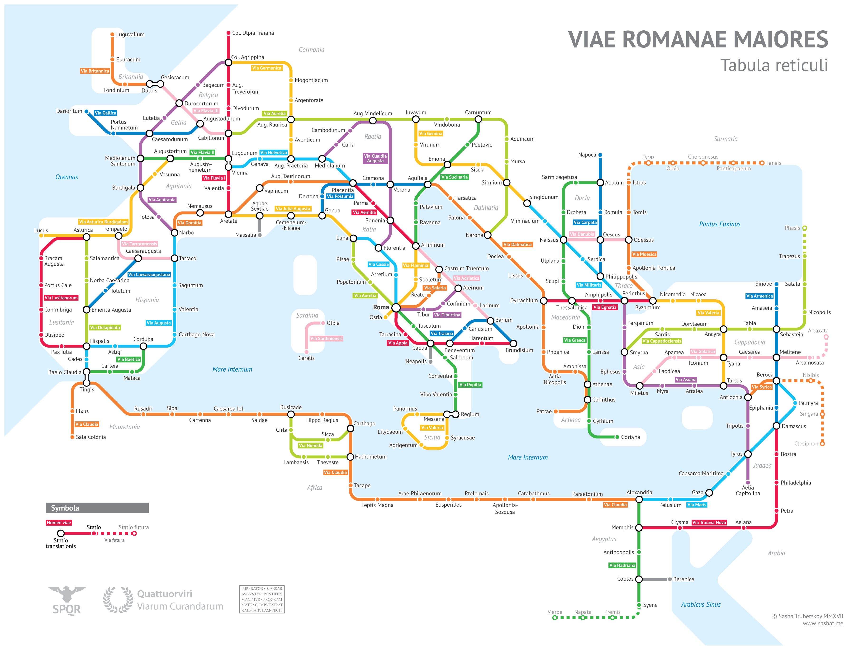
His site has the same resolution, it's just scaled down on the page: https://sashamaps.net/images/roman_roads_original.png
The Roman Empire was very advanced for the time, and it left such a huge imprint on the civilization even centuries, and thousands of years after it.
The organization was a different scale.
Fun fact: Some of the most famous battles in England in the middle ages, such as battle of Hasting, were basically 5k - 9k soldiers in each side. That's just one and a half Roman legion.
Rome, could field 12 legions at a time, and the scale was insane. I can see why the Roman Empire remained such a symbol of civilization for a thousand of years after its fall.
Pictures like this make me think of all the different types of empire that have existed over the millennia. For example, you couldn't make a map like this of the Golden Horde because nomadic societies aren't nearly as road-obsessed as sedentary ones (see: ours).
People are too obsessed with comparing every other empire to Rome. I remember going to a museum with my friend who is an archaeologist and there was a fantastic exhibit on the Incan Empire. I was really enjoying it, but he was frustrated by how much of it was devoted to arguing that the Incan Empire was as cool as the Roman Empire on the latter's terms. "I don't want to hear about how the Inca were similar to the Romans. I want to hear about how they were different." That really stuck with me.
The original creator's page is: https://sashamaps.net/docs/maps/roman-roads-original/
The summary here links right to the original content. I just wanted to highlight the original for the sake of other readers clicking through quickly. There's also a much more detailed (and more interesting) writeup on the creator's page.
All hail Harry Beck, who invented these maps
https://tfl.gov.uk/corporate/about-tfl/culture-and-heritage/...
If you want to cause controversy and stir up some trouble in the ancient history community there's nothing like the topic of Roman roads. I didn't realize it until reading up on the subject. There seems to be two camps the "ancient aliens" type who argue Roman roads were built and lasted 2,000 years vs the roads were continually repaired over 2,000 years just like any other road.
We have a very good expert in Spain
He have this old web : https://viasromanas.net/ with very good maps and this one https://www.traianvs.net/
[Traslate to english from wikipedia] Isaac Moreno Gallo (1958- )1 is a Spanish engineer, historian and communicator.
Isaac Moreno is a Public Works technical engineer and graduate in Geography and History. He works in the Spanish Ministry of Development. He has carried out various projects to identify and study Roman infrastructure, especially Roman roads and hydraulic infrastructure. He has worked for various public administrations as a specialist in Roman engineering and carried out research on ancient technique, ancient topographical instruments and other facets related to this engineering.2
He has written several specialized books and participated, as a presenter, in television programs on Roman engineering. He maintains a YouTube channel where he publishes informative videos of his research.
https://es.wikipedia.org/wiki/Isaac_Moreno_Gallo
https://www.youtube.com/@IsaacMorenoGallo
If you want to see more he have this documentary serie in full english. Called "Roman enginering"
https://youtu.be/MNU40dq5B0U?si=wbpfZa5MVG5O0oMQ
For me he is one of the greatest experts in Roman engineering in the world.
Me myself maybe the only one here who used Roman Roads for effective travel. I bicycled from Finland to Yugoslavia in 1971. Roads were often just mud for tanks and lorries. But sometimes I found small roads with flat stones. Especially I remember the road between Ljubjana and Udine. There was quite wide road sections in the middle of nowhere completely paved with stones. This was the Main Roman Highway between EMONA and AQUILEIA says the map (https://imperium.ahlfeldt.se/index.php?id=10717). I truly wondered who the hell has built this road, because I did not know shit about any Romans.
That's really well done! I have no comment on the accuracy but it really highlights just how the Romans integrated new areas into the central empire through transportation (goods, ideas, and armies).
I will also call out the road in Africa called "Caeserea lol"
This is really neat! Thanks for sharing. I wonder if there's an analogue for these routes and the roadway system there? I imagine so. I thought it was interesting how short Via Appia was. Learning Latin growing up, I imagined that to be much longer.
How can it take 2 months on foot, yet only 1 month per horse, when a horse can only travel between 25-35 miles a day, which is not twice as far as a human can travel in a day, but about equal?
There's a series on Amazon Prime where a Brit actually travels the main Roman Roads in England, revisiting the history while he goes.
They actually demonstrate how they got the roads so straight.
Very schematic from region I live around - Geneva and Aosta are not that far on the map and seem close neighbours, but highest part of alps lies in between, passes can be brutal and far apart (>=2500m high, ie St Bernard pass from where famous dogs come from, can end up snowed anytime all year round and especially 2000 years ago, at least 6 months/year unpassable for carriages and dangerous for anything else).
I checked and I think they are missing King’s Highway:
https://www.audleytravel.com/jordan/country-guides/the-kings...
Was it not Roman enough, ie not built by Romans so not on the map? Or did it not exist during Roman times?
Cool visualization.
From the title I thought it would be this project (called "roads to Rome"): https://benedikt-gross.de/projects/roads-to-rome/
I don't know if "Genava" is the same as modern day Geneva CH, but if it is, then how is can it be correct to show Vienna to the west of it? I get that a subway map abstracts the physical layout, but surely this is a mistake in the topology??
Naissus represent! I love this. Testament to Harry Beck's circuit board mapping approach - so easy to read. With Roman roads being far more 'straight' than London tube lines, it's even more suitable.
Many of the roads in Europe between cities are former roman roads. Sometimes you can even see ancient small bridges along the bigger highways.
The romans cut out entire mountains to guide roads through. Amazing work.
It seems you're missing Via Gallica https://en.wikipedia.org/wiki/Via_Gallica
There's a missing road in Sardinia that I'm aware of, connecting Karalis (today's Cagliari) with Turris Libisonis (today's Porto Torres, near Sassari).
I guess Darioritum is how they got to Asterix' place...
Ulpiana - still relevant in Kosovo
Dyrrachium - Durres - modern day Albania
Lissus - Lezha - MOdern day Albania
I was about to complain that my hometown is missing, but then remembered it didn't exist back then.
Interesting choice making Gaza so prominent and not including Jerusalem
Omnes viae Romam ducunt.
How does this compare to the modern rail system?
Romaaaaan roads. Take me hoooome...
Why is Geneva east of Vienna?
LOL, Pompeii (closed)
"Caesarela lol"? WTF is this station? :'D
Great job
absolutely love this. well done
Coincidentally, this is also the future hyperloop map.
Sometimes I wonder if we've regressed in terms of attention to quality. Here in the US, I see lots of potholes on the streets and sidewalks. Meanwhile, the ancient cobblestone roads are still functional to this day.